




ShipFinder provides real-time cargo ship tracking through terrestrial and satellite AIS, covering more than 200,000 vessels worldwide. Check vessel positions and ETAs, review historical tracks and port calls, and receive event alerts to stay informed as voyages progress.
What You Need Before Tracking a Cargo Ship
Identify the Vessel Carrying Your Cargo
Start with the vessel's name, IMO number or MMSI. If you only have a container number or shipment reference, ask your carrier or freight forwarder, or check your shipping records, to identify the vessel.
For shipments involving transshipment, confirm which vessel is carrying your cargo on the current leg. A vessel listed earlier in the journey may no longer be the one you need to monitor.
Distinguish Vessel Tracking from Shipment Tracking
Vessel tracking shows a ship's reported position, movements and port calls. Shipment tracking follows transport milestones for a specific shipment or container.
Use both when checking cargo progress. A vessel's arrival at port does not, by itself, confirm that your cargo has been discharged, cleared through customs or made available for collection.
How to Track a Cargo Ship with ShipFinder
Step 1: Open ShipFinder
Open the ShipFinder vessel map to begin your search. If you want to keep vessels together for regular monitoring or enable satellite tracking, please create a free account to continue.
Step 2: Search by Vessel Name, IMO Number or MMSI
Enter the vessel's name, IMO number or MMSI and select the matching result. Check the vessel's MMSI or IMO number before following its movements, particularly when several ships have similar names.
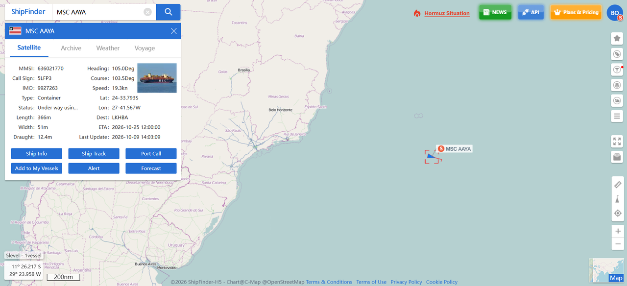
Step 3: Check the Latest Position and Voyage Details
Open the vessel information panel and review these details together:
Position and report time: Where the vessel was last reported and how recent that report is
Speed and course over ground: How fast the vessel was moving and in which direction
Destination and ETA: Its reported destination and estimated arrival time
Read the position alongside its last update timestamp. A marker on the map represents a reported location; the timestamp helps you judge whether it is recent enough for your needs.
For a broader introduction to these features, see our guide to tracking vessel movement with ShipFinder.
Step 4: Review the Route and Recent Port Calls
Check historical tracks and recent port calls to understand the movements leading up to the latest position. You can identify the previous port visited and review the vessel historical tracks.
Historical tracks: View recorded vessel movements over the available period.
Port calls: Check recorded port visits, including arrival and departure times.
Playback: Replay the vessel's recorded movements.
Route forecast: View the predicted onward route.
Historical tracks show recorded activity, while a route forecast estimates the route ahead. The historical period available depends on your plan.
Step 5: Enable Satellite Tracking for Offshore Voyages
Satellite AIS helps you follow a cargo ship after it sails beyond the range of coastal receivers. To receive offshore position updates, make sure your account has an available satellite tracking slot, then add the vessel to satellite tracking. Otherwise, you may continue to see its last terrestrial AIS position.
The free Basic plan includes satellite AIS tracking for one designated vessel. Follow our guide to activate your free satellite tracking, or explore the ShipFinder plan comparison if you need to monitor more vessels offshore.
Tips for Following Cargo Ship Movements
Check the Last Update Time
Check the report time whenever you review a position, especially before using it to update transport arrangements.
Read ETA Alongside Your Shipping Schedule
Compare the vessel's ETA with your carrier's schedule and any subsequent inland transport arrangements. An ETA is an estimate of vessel arrival, not a confirmed delivery or cargo collection time.
Set Alerts for Relevant Vessel Events
Set up alerts for events you need to follow, such as arrivals, departures, area entry or exit, and speed changes. Email notifications help you keep track of relevant activity without repeatedly opening the map.
Keep Relevant Vessels Together
Use the available map filters to narrow your view, and add the ships you regularly follow to a fleet. A fleet list makes it easier to return to those vessels without repeating individual searches.
For workflows involving several ships, see our guide to real-time ship monitoring for commercial fleets.
What to Check If a Cargo Ship's Position Has Not Updated
Check the report timestamp: Review when the position was last reported and whether the vessel is within coastal coverage or sailing offshore.
Confirm satellite tracking is enabled: For offshore vessels, make sure the ship has been added to satellite tracking and your account has sufficient capacity. Otherwise, you may still see its last terrestrial AIS position.
Consider other factors affecting AIS updates: Transmission intervals, receiver coverage, signal reception and data delivery can affect when new reports become available, even when satellite tracking is enabled.
Start Tracking Your Cargo Ship
Open ShipFinder vessel tracking live map to search for your cargo vessel and check its latest position and voyage details. Create a free account to explore the tracking tools and enable satellite AIS tracking for one designated vessel.
FAQ
Can I track cargo ships for free?
Yes. You can use ShipFinder to check cargo ship positions for free. To follow a vessel offshore, just create a free account and activate free satellite AIS tracking for one designated vessel.
Can I track a cargo ship using a container number?
Search ShipFinder by vessel name, IMO number or MMSI. If you only have a container number, use your carrier's shipment tracking service or contact your freight forwarder to identify the vessel carrying it.
Are cargo ship positions updated in real time?
ShipFinder displays the latest available AIS reports. Their freshness depends on reception, data availability and your account's access to the relevant tracking services.
Can I track cargo ships while they are offshore?
Yes. ShipFinder provides offshore position updates through satellite AIS. To receive updates, add the vessel to satellite tracking and make sure your account has an available slot. The free Basic plan includes satellite tracking for one designated vessel, while paid plans let you follow more vessels offshore.
Can I view a cargo ship's previous route and port calls?
Yes. ShipFinder lets you review a cargo ship's historical tracks and port calls. A free Basic account includes three days of history, with longer periods available on paid plans.